
If you’re asking where are the wildfires in north carolina, you’re not alone. Fire activity shifts week to week across the Mountains, Piedmont, Sandhills, and Coastal Plain, and conditions can change by the hour. Spring and fall bring the most risk, and specific spark points vary—from rugged national forest ridges out west to windy, fast-moving brush fires in the Sandhills and even deep-burning peat fires on the coastal pocosins. During active periods, officials may close trails, post air-quality alerts, or restrict outdoor burning in certain counties. Knowing where are the wildfires in north carolina today starts with using the right tools and understanding the state’s fire patterns.
In this guide, you’ll get a quick, scannable view of likely hotspots, how to check official live fire maps, when and why fire danger spikes, and how to read containment updates. You’ll also learn the difference between wildfires and prescribed burns—planned fire that reduces fuel and protects habitat. Most importantly, you’ll leave with practical steps for staying informed and prepared, whether you’re planning a hike in Pisgah, living near the Uwharrie, or commuting across the Sandhills. Let’s track what’s happening, where it’s happening, and how to stay safe without getting overwhelmed by jargon or rumor.
Where are the wildfires in north carolina?
They’re most often in the western mountains (Pisgah & Nantahala), the Sandhills, and occasionally the coastal pocosins. Locations change daily. Check the N.C. Forest Service Wildfire Viewer for live incidents, InciWeb for larger fires, and the AirNow Fire & Smoke Map for smoke. Always follow local burn restrictions and safety alerts.
North Carolina Wildfires Patterns Regions and What They Mean
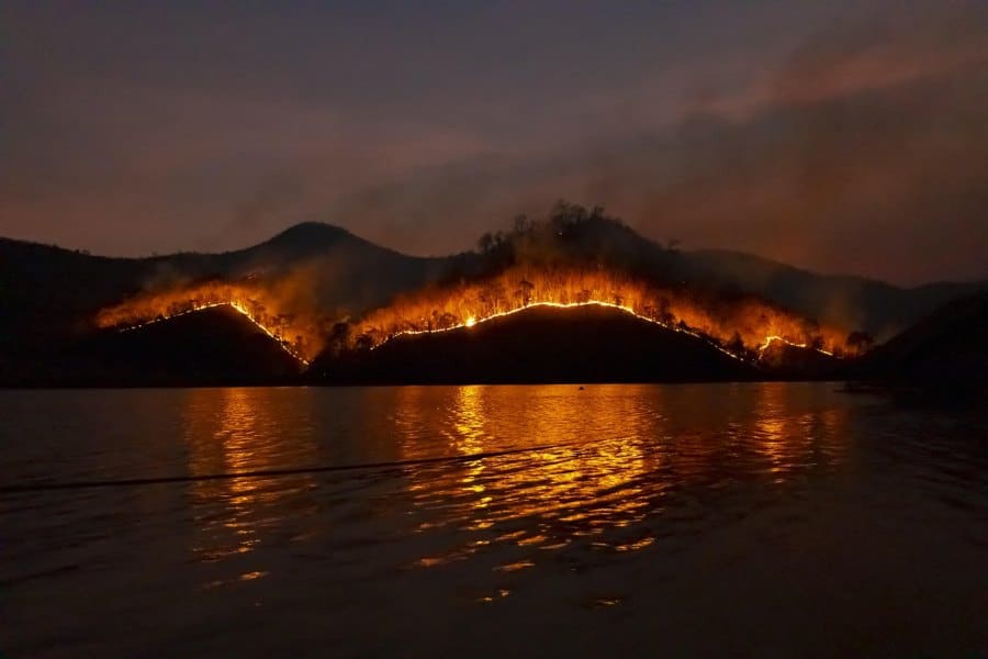
Wildfire risk in North Carolina varies by region and season. In the west, steep mountain slopes, deep leaf litter, and gap winds push flames uphill—especially in early spring before green-up and in late fall after leaf-drop. When people ask about current fire locations, firefighters often point to ridgelines and canyons in and around Pisgah and Nantahala National Forests, plus adjoining private lands where access is limited.
Across the Piedmont, location questions usually trace back to human sparks on breezy, dry afternoons—escaped debris burns, roadside ignitions, or equipment use near cured grasses. Fires here can move quickly through understory and along greenway edges or utility corridors, prompting short-lived road advisories and neighborhood smoke concerns, even when overall acreage stays modest.
Because most North Carolina wildfires are human-caused, prevention shapes the “where.” Timing debris burns, watching wind forecasts, and clearing fuels around homes reduce starts in the very places that see the most incidents. For small businesses that need continuity plans during active fire periods—closures, smoke days, staffing contingencies—consult trusted local resources such as pedro paulo business consultant to formalize checklists and communication playbooks that keep teams and customers informed.
North Carolina Wildfires Today Maps Closures and Smoke
Get a real-time picture before you head out: check the N.C. Forest Service Wildfire Viewer for active incidents, confirm big fires on InciWeb, and track smoke on AirNow. Turn on ReadyNC alerts so updates on closures, air quality, and road conditions reach you fast on high-risk days.
Use the N.C. Forest Service Wildfire Public Viewer
This is the state’s official, near-real-time map of reported and active wildfires. It’s the best first stop for a county-by-county snapshot—especially during active spring and fall periods. Bookmark it and zoom to your county before you travel or burn.
Verify Large Incidents on InciWeb
Major incidents—especially on federal lands—are posted to InciWeb with updates, maps, and closures. If a national forest trail or area is closed, you’ll typically see a notice here along with containment percentages and public information contacts.
Track Smoke with the AirNow Fire & Smoke Map
Even if there’s no fire in your county, regional smoke can impact health. AirNow’s map shows particle pollution and smoke plumes so you can adjust outdoor plans or masks if needed. This pairs well with the state viewer for a fuller picture.
Add Alerts via ReadyNC
ReadyNC centralizes emergency updates—weather alerts, evacuations, shelters, road conditions. Use it during high-risk days so checking conditions becomes a quick routine, not a scramble.
County-Level Hotspots & Seasons—Timing the Risk
A single map never tells the whole story. Before you head out, match place with season and fuels. That’s how you turn broad patterns into practical choices—what roads to avoid, which trails to check, and when to postpone debris burning.
- Mountains (Pisgah & Nantahala) — Spring and late fall are the peak windows. Expect lightning-caused starts in remote terrain and human-caused fires near roads, trailheads, and private inholdings. Rugged slopes mean fires can move fast on windy days; trail and area closures are common, as seen in 2025.
- Foothills & Piedmont (Uwharrie, lake belts, urban edges) — Windy, dry afternoons plus yard cleanup equals risk. Near Charlotte–Triad–Triangle, scan the state viewer for brush fires along roads, utility corridors, and neighborhood woodlots.
- Sandhills (Longleaf Pine Country) — Fire-adapted landscapes mean lots of planned burns in late winter–spring. Wildfires happen when winds spike or burns escape. Many residents smell smoke regularly; check maps to confirm whether it’s prescribed or unplanned.
- Coastal Plain (Pocosins & peat) — Fewer starts but potentially long-lasting smoke events in drought. Along the coast, monitor smoke and air quality first—peat fires can be deceptive even with small perimeters.
- Tourist Corridors (Blue Ridge Parkway, Joyce Kilmer, popular loops) — Trail closures pop up quickly around active incidents; always verify before driving hours to a trailhead. InciWeb is your friend for closures and maps.
- Wildland-Urban Interface (WUI) neighborhoods — Leaf litter, pine-straw mulches, and wood fences create ember pathways. If neighbors burn debris on breezy days, risk rises right where you live. Prevention—timing, permits, and prep—matters most.
North Carolina Wildfires Causes Readiness and Home Prep
Even a perfect map can’t predict tomorrow’s starts. In North Carolina, people cause the vast majority of wildfires—nearly all of them. That means the hot spots often track with human activity: yard burning, equipment sparks, and unextinguished campfires. On dry, breezy days—especially in spring before leaf-out or in autumn after leaf-drop—light fuels cure quickly and carry flame into shrubs and trees. Ask for today’s likely trouble spots on those days, and responders will point to roadside grasses, wooded subdivisions, and trailhead parking areas that collect embers. The good news? Prevention works, and small actions stack up.
Start with the basics. Use ReadyNC to set up emergency notifications. If you plan to burn debris, follow local rules, pull permits if required, check the forecast, and never burn on windy, low-humidity afternoons. Keep water, a shovel, and a clear safety zone on all sides of your pile; stay with it until it’s cold to the touch. If you live in a WUI neighborhood, swap flammable mulches near structures, screen vents, clear gutters, and prune ladder fuels under trees so ground fire can’t climb into crowns. Mark your driveway and address clearly for engines; keep access wide for large vehicles. Teach kids fire safety and post emergency numbers somewhere visible. These simple steps make a measurable difference, and they’re the same actions firefighters ask for after every busy week.
North Carolina Fire and Smoke Checklist Before You Go
Before you head out, do a quick safety check. Use the NC Wildfire Map for active incidents, verify big fires on InciWeb, and scan AirNow for smoke conditions. This simple routine helps you plan safer travel, outdoor time, and yard work across North Carolina.
- Live NC Wildfire Map (State Viewer) — current incident locations
Zoom to your county for active reports; refresh before you drive. - InciWeb Updates — federal lands & big incidents
Use for trail closures, maps, and daily updates (Pisgah, Nantahala, Uwharrie). - Air & Smoke — plan your day
Check AirNow’s Fire & Smoke Map for downwind impacts even if nothing’s nearby. - Seasonal Timing — spring & fall spikes
Expect more reports in March–April and again after leaf-drop in October–December. - Human Causes — debris burns lead statewide
Most fires are preventable; time your yard work carefully and follow local guidance.
Conclusion
Fire activity in North Carolina is dynamic, but it isn’t random. Mountain slopes, Sandhills wiregrass, and coastal peatlands each respond to weather and season in predictable ways. When you know the patterns—and where to pull live maps—you can answer the real-time question behind every headline: the North Carolina wildfire locations that matter to your plans today. Check the state viewer and InciWeb before you head for the woods, keep ReadyNC handy for alerts, and practice backyard fire safety. With that simple routine, you’ll navigate risk confidently and help reduce the number of new starts across the state.
FAQ’s
How do I quickly find fires near me in NC today?
Open the N.C. Forest Service Wildfire Public Viewer and zoom to your county; then cross-check big incidents on InciWeb and smoke on AirNow.
When is North Carolina’s wildfire season?
Risk peaks in spring (March–April) and rises again in fall after leaf-drop, though fires can occur any time during dry, windy spells.
What causes most wildfires in the state?
Nearly all are human-caused, especially escaped debris burns. That’s why timing, permits, and on-site tools (water, shovel) matter.
Why do mountain fires get so much attention?
Steep terrain, wind, and remote access make western fires harder to contain and more likely to trigger trail/area closures during busy periods.
Are there statewide burn bans when it’s bad?
Burn bans are set as needed and may be local or statewide. Always check the Wildfire Situation Report and county guidance before burning.


